[On January 13, 2020, Mayor Byron Brown’s Office of Strategic Planning (OSP) provided its “Staff Report” – transcribed in its entirety below – regarding Gerald Buchheit’s proposed 20-story tower to the City Planning Board shortly before the opening of the board’s meeting. The Planning Board was scheduled to determine – without public input – three important matters relating to Queen City Landing’s proposed Planned Unit Development (PUD)/rezoning application at 975-1005 Fuhrmann Blvd.: first, recommend to the Common Council whether to approve or disapprove the proposed PUD; second, render its SEQRA “Determination of Significance” deciding whether to require the applicant to prepare a draft Environmental Impact Statement or end the environmental review; and, third, conduct a “Consistency Review” to determine if the proposed project complies with the goals and objectives of the City’s Local Waterfront Revitalization Program (LWRP).
In theory, the staff report is intended as an objective assessment of the proposed project by the city’s planning office professionals. From my experience, the report is heavily relied upon by Planning Board members as they review a pending application, and it often forms the bases for the board’s “findings of fact” on a pending application.
It is clear to me that staff report on the QCL project is not a balanced assessment of the PUD application. To help correct that deficiency, I will annotate the “staff report” below to provide additional information or perspectives not shared by the OSP staff with the Planning Board members. To limit any confusion, the text of the staff report will be underlined below. My bracketed and italicized comments will follow each paragraph of the staff report.
For the record, I have opposed (see, for example, Giacalone Letter to Common Council 01-02-20), and have assisted environmentalists and Outer Harbor activists in opposing, the various iterations of Mr. Buchheit’s Queen City Landing tower projects. Thanks. Arthur J. Giacalone, Attorney-at-Law and South Buffalo resident.]
CITY OF BUFFALO
PLANNED UNIT DEVELOPMENT
Property Location/Name: Queen City Landing (975 Fuhrmann Blvd.)
Proposed Use: Mixed Use building
Existing Zoning: N-1S Secondary Employment center/C-W Waterfront corridor
Surrounding Zoning: N-1S, D-OG (Open Space – Green)
Existing Land Use: Vacant land
Surrounding Land Use: Vacant land, park, marina
Action Requested: Planned Unit Development
Date of Public Meeting: January 13, 2020
Summary
The proposed project includes the development of a 20-story mixed use building on the former Freezer Queen industrial site along the Lake Erie waterfront. The project includes 35,000 SF of restaurant, retail, and commercial space on the ground floor, structured parking on floors two through five, 19,000 SF of restaurant/banquet space of [sic] the sixth floor, and 206 residential units above the sixth floor. In addition, the site will include a ground floor waterfront terrace, surface parking, public bike and walking paths that connect [with] the existing multi-use waterfront trail along Fuhrmann Blvd., as well as a public marina.
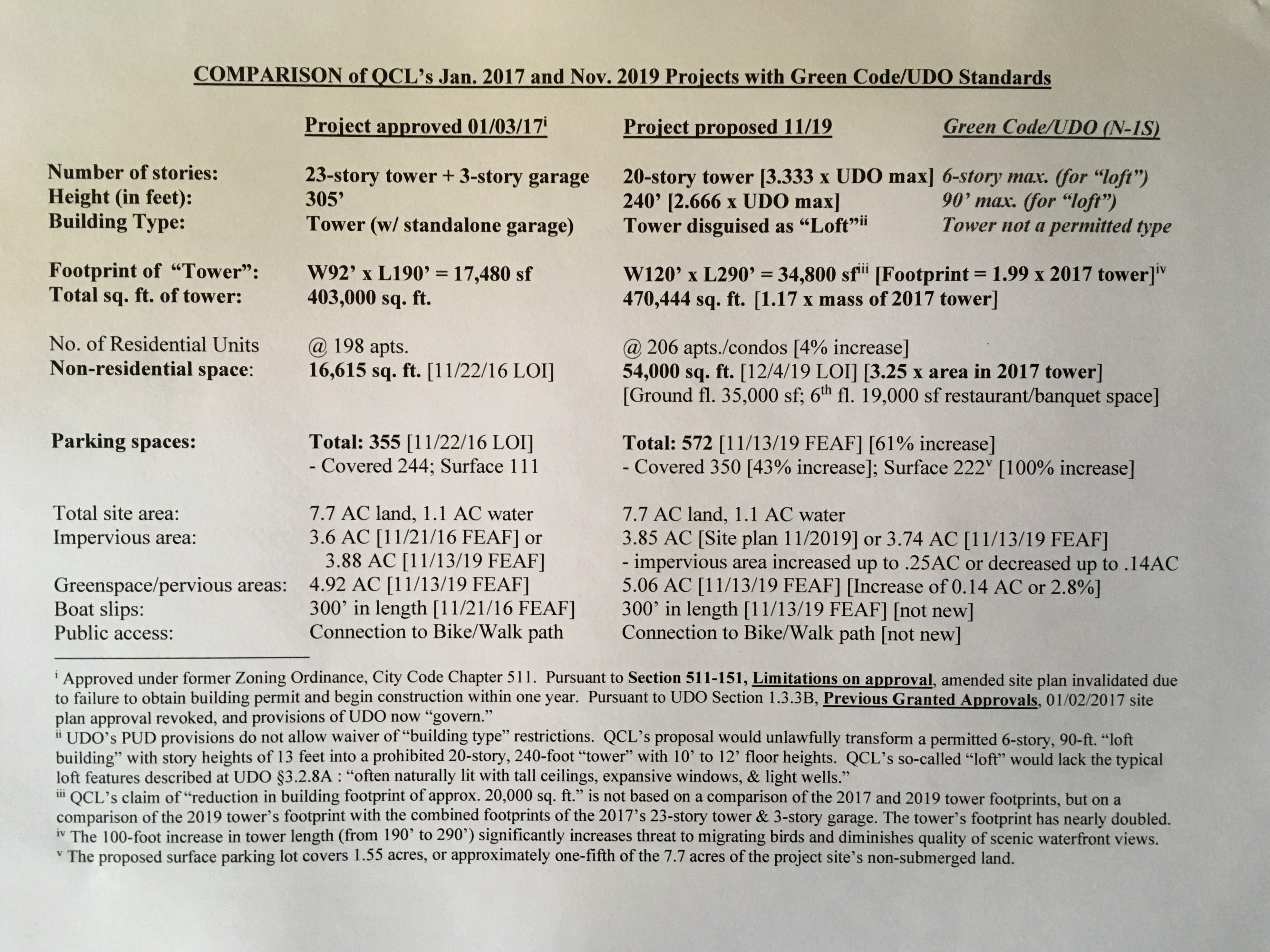
[- The proposed 54,000 SF of restaurant, retail, commercial and banquet space more than triples the 16,615 SF of non-residential space approved in 2016/2017.
– To accommodate the increased commercial/non-residential activities, the 2019 project proposes a 61% increase in total parking spaces – from 355 to 572 – including a doubling in surface parking spaces from 111 to 222-vehicles, requiring a surface parking lot covering more than an acre-and-a-half of land.
– The number of residential units has increased from 198 to 206.]
Background
The City previously approved a plan for a 23-story building in May 2016 (the current plan reduces the building height by three stories/48 feet, integrates the stand along [sic] parking structure into the principal building, reduces the building footprint and impervious coverage of the site, while increasing the green space).
[- The 2016 and 2017 approvals of the prior project were approved under the former zoning ordinance. Pursuant to Section 511-151 (“Limitations on approval”) of the former code, the Planning Board’s January 3, 2017 amended site plan approval was rendered invalid when the applicant failed to obtain a building permit and commence construction within one year of the site plan’s issuance. In accordance with UDO Section 1.3.3B (“Previously Granted Approvals”), the project’s previous approval is revoked, and the provisions of the UDO govern.
– While the combined footprint of the 3-story standalone parking garage plus the 23-story tower approved in 2016 is smaller than the footprint of the proposed structure, the footprint of the proposed structure is twice the footprint (width-times-the-length) of the previously approved tower (approx. 34,800 SF vs. approx. 17,480 SF), the proposed structure is 100 feet longer than the 2016/2017 version (290’ vs. 190’), and the gross floor area of proposed structure is 67,000 SF greater than the 23-story tower.
– If the applicant’s FEAF is correct, the decrease in impervious surfaces is less than one-seventh of an acre (0.14 AC), from 3.88 AC to 3.74 AC. However, if QCL’s Nov. 2019 site plan is accurate when it identifies the impervious area as 3.85 AC, the decrease is only 0.03 AC.
– As a result of the significantly larger footprint of the proposed building, and the doubling of service parking spaces, the increase in greenspace/pervious areas is less than one-seventh of an acre (0.14 AC).]
Consistency with the Comprehensive Plan
Standard 1: The planned unit development is consistent with the spirit and intent of this Ordinance and the Comprehensive Plan.
Analysis: The proposed project is consistent with the Comprehensive Plan’s policy of Transforming Buffalo’s Economy and specifically its priority to clean up and redevelop brownfield sites. In addition, the project may align with the Comprehensive Plan’s policy to Restore Ellicott, Olmstead, and the Waterfront, specifically its priority to reconnect to the waterfront by improving waterfront access and leveraging waterfront assets for appropriate economic development. However, there is some public sentiment that residential development on the Outer Harbor is inappropriate but the use of the site as mixed use is allowed by right.
[- In 2006, the Common Council adopted “Buffalo’s Comprehensive Plan – Queen City in the 21st Century.” It was based on “a set of key principles”: sustainability, smart growth , and two simple rules, “fix the basics” of municipal service delivery and maintenance of the urban environment, and “build on the assets” of the community and great urban heritage. It can be argued that the PUD application is inconsistent with most, if not all, of these key principles.
– It may be a stretch to claim that the proposed project is consistent with the Comprehensive Plan’s policy of “Transforming Buffalo’s Economy.” T he full statement of the policy is as follows: “3. Transform the city’s economy to meet the needs and opportunities of the 21st century and to provide the material basis for the revitalization of the whole city.” The proposed PUD’s combination of residential units, retail, and restaurant/banquet space is hardly transformative, or focused on the city’s 21st century needs and opportunities.
– The UDO defines the city’s comprehensive plan as much more than any one document (as implied by the staff report’s reliance on a single policy from the 2006 “Queen City in the 21st Century”): That is, “Comprehensive plan. The materials, written and/or graphic, including maps, charts, studies, resolutions, reports, and other descriptive materials that identify the goals, objectives, principles, guidelines, policies, standards, devices, and instruments for the immediate and long-range protection, enhancement, growth, and development of the City of Buffalo, which have been adopted and may be amended by the City in accordance with the General City Law.” The UDO itself, and Buffalo’s LWRP (Local Waterfront Revitalization Program) fall within this definition of the city’s comprehensive plan.
– A strong argument could be made that the PUD application is inconsistent with numerous policies and objectives set forth in Buffalo’s LWRP, including, for example:
– Protect and enhance features which contribute to the LWRA’s scenic quality (such as marinas, piers, wharfs, sunsets, and unique waterfront landscapes).
– Protect significant fish and wildlife coastal habitats (Small Boat Harbor, Tifft Nature Preserve, and Times Beach Nature Preserve).
– Protect the Niagara River Globally Significant Important Bird Area.
– Avoid disruptions to bird migration by the maximum extent practicable.
– Maximize coastal resiliency.
– Consider potential impacts of climate change on Buffalo’s coastal area.
– Minimize property damage and risk to humans from flooding and erosion.
– Maintain and protect shoreline protective features.]
The proposed PUD is located within the UDO’s N-1S Secondary Employment zone. Per the UDO, the N-1S zone addresses “mixed use employment centers primarily located along the New York Central Belt Line, often defined by mid-rise and large footprint industrial structures.” While the proposed PUD is consistent with the N-1S zone’s call for intensive mixed-use development, it should be noted that the site is not located along the Belt Line and its context is not defined by mid-rise industrial buildings (though the site once contained such a structure).
[- When determining whether the proposed construction of a 20-story building at 975/1005 Fuhrmann Blvd. is inconsistent with the spirit and intent of the UDO, one cannot overlook the fact that the following standards were established by the Common Council for the N-1S zoning district: the exclusion of “Tower” as a permitted building type; and, the 6-story and 90-foot height limited for the allowed building types, “loft building” and “civic building.” More broadly, the UDO’s exclusion of “towers” from all districts other than N-1D (the downtown district) reflects an intent to exclude buildings of the proposed 20-story structure’s substantial height and density from the N-1S and all districts other than N-1D.
– “Building Type” is not among the regulatory categories that an applicant may apply to waive or modify under the UDO’s PUD provisions. As noted, a tower is a building type not permitted in the N-1S zone. The public has strongly questioned whether the applicant’s characterization of its 20-story building as a “loft” is an improper effort to circumvent the UDO’s prohibition against constructing a tower in the N-1S zone, and the Common Council’s lack of authority to waive a” building type” restriction when establishing a PUD. It should be noted that, under the UDO, the maximum height allowed for a loft building in any zone is 6 stories, and the applicant’s proposed 20-story “loft” lacks the following features associated with lofts: naturally lit, tall ceilings, expansive windows, and light wells.
– It should also be noted that the applicant’s architect, Duncan Bates, referred to the proposed structure as a “residential tower” when testifying at the January 14, 2020 public hearing before Common Council’s legislative committee.]
Land Use
Standards (sic). 2. The planned unit development allows for the creative and innovative development of property that would otherwise not be possible through strict application of the standards of this Ordinance. 5. The planned unit development will maximize transportation efficiency. 6. Whether the planned unit development will provide for public benefits not otherwise required by this Ordinance. 7. The planned unit development will be sufficiently served by or provide services, utilities, and infrastructure as required by the Buffalo Sewer Authority, Buffalo Water Board, Department of Public Works, Parks, and Streets, and Fire Department.
Page 1 of 2
Analysis: The proposed PUD allows for additional building height in order to take advantage of the vast waterfront views, while incorporating a mix of uses including restaurant, retail, and other commercial activities which would likely serve as a waterfront attraction. The waterfront site is accessed by one road and would generally require automobile access due to limited transportation alternatives in the area most of the year. The applicant states the public benefit includes public pathways which will connect to the existing multi-use pathway along Fuhrman (sic) Boulevard and will loop around the proposed building which would provide additional public waterfront access. The project also proposes a public marina and a waterfront terrace at the ground level as a public benefit or amenity. As stated in the previous (sic) adopted negative declaration the proposed PUD will be sufficiently served by or provide services, utilities, and infrastructure as required by the Buffalo Sewer Authority, Buffalo Water Board, Department of Public Works, Parks, and Streets, and Fire Department though additional extensions may be required to service the site.
[- The proposed PUD does not appear to offer “creative and innovative development” of the parcel, and differs little conceptually from the project approved under the old zoning ordinance. Combining residential, retail and restaurant/event space in the same building is hardly creative or innovative when each of the uses is permitted in the N-1S zone, and the concept of “mixed-use” buildings is a cornerstone of the UDO/Green Code.
– The applicant’s Letter of Intent states that the sixth-story restaurant/banquet space will provide guests “with spectacular views of the waterfront,” and “will impress guests with a unique and picturesque experience.” Given the scenic waterfront views available from the sixth floor, it appears that occupants of floors 7 through 20 could be afforded notable waterfront views without being located on land situated in close proximity to the Lake Erie shoreline.
– The PUD proposal fails to offer the noteworthy types of public amenities listed in the UDO, such as affordable housing units, below-market commercial incubator space, green building systems, adaptive reuse of heritage resources, reserved or dedicated open space, accessible building and site exceeding USAB minimum standards, use of renewable energy sources, water conservation and reuse, or restoration of natural features. Also, the Brownfield cleanup of the site occurred prior to the proposed PUD application, and, therefore, would not be a product of the creation of the PUD.
– The applicant does not dedicate any part of the site to public use, but is merely allowing the public to bike or walk on its multi-use path and use its boat slips. These same amenities – a bike/walking path looping around the principal building, and 300 feet of boat slips – were part of the 2016/2017 project. There appears to be no reason that they could not be a part of a project under the UDO without creation of the requested PUD.
– It is difficulty to suggest that the proposed PUD would “maximize transportation efficiency” when the site would generally require automobile access due to limited transportation alternatives in the area most of the year. The applicant’s TDMP describes the project site as “Car-Dependent” with “Almost all errands requiring a car” and a “Walk Score” of 1 on a scale of 0 to 100 (with 100 representing the highest rated location), and as “Minimal Transit” with a “Transit Score” of 21 out of 100. While “it is possible to get on a bus,” the closest bus stop is near the Small Boat Harbor, and no current bus route is available to stop at the project site.]
Compatibility
Standard 3. The planned unit development will be compatible with, and not impede the normal and orderly development and improvement of, adjacent property. 4. The planned unit development will promote a coordinated site and building design to enhance the relationship of buildings to public space, the interconnectedness of rights-of-way and blocks, and social vitality.
Analysis: Much of the surrounding area is zoned for Open Space and will therefore have very limited development. The provision of residential adjacent to open space could provide a built in constituency and user group for the open space or could potential (sic) create conflicts depending on the use of the open space. The project will provide public access pathways along the waterfront that will connect to nearby waterfront attractions via the existing multi-use waterfront trail. A public marina will be incorporated, providing a public amenity. Although the PUD shows how the site would relate to the public right-of-way it lacks detail about the development of the rest of the peninsula which could help to determine if the entire parcel will be developed in a coordinated manner.
Page 2 of 2 [End of Staff Report]
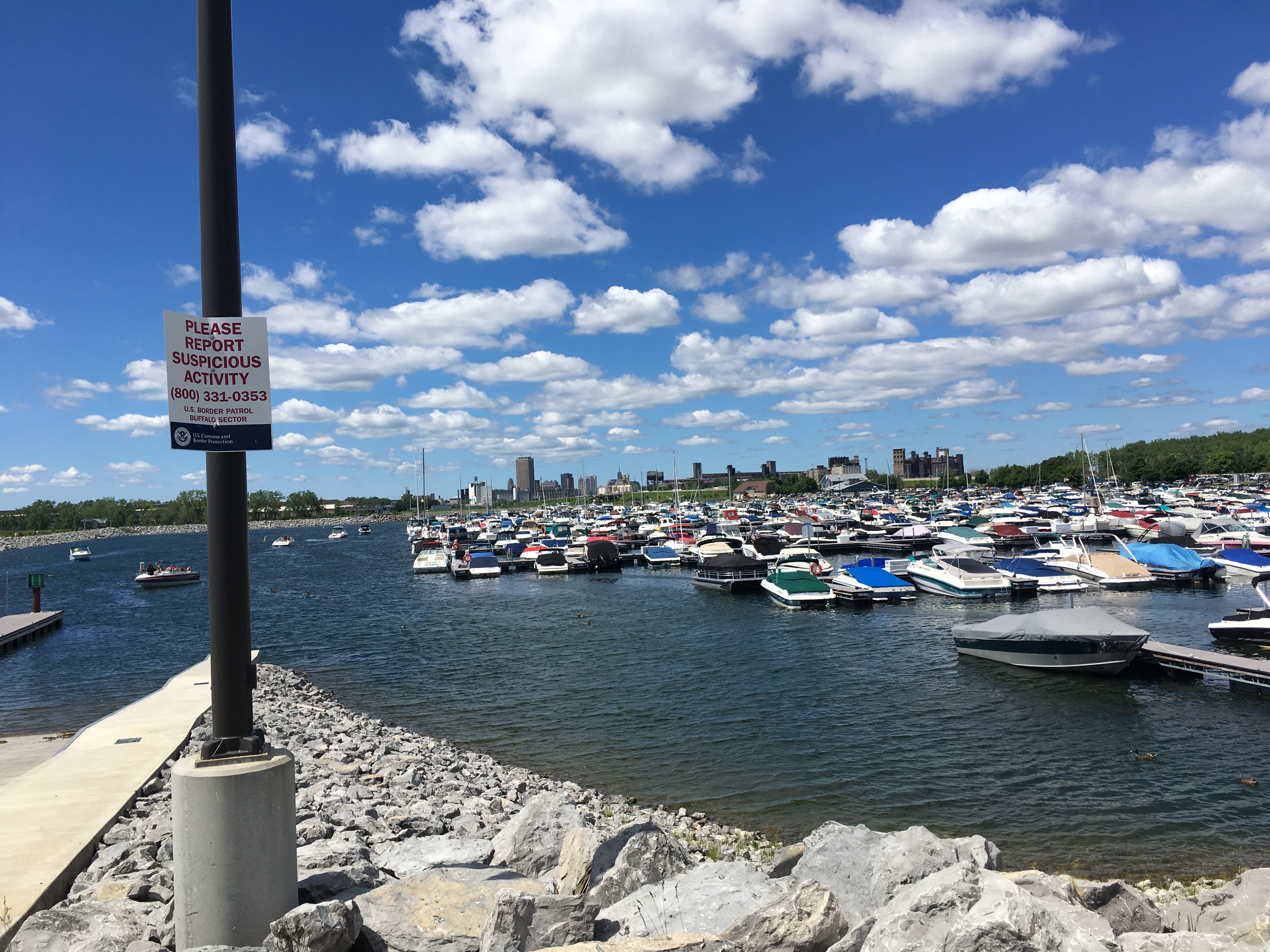
[- Strong public sentiment has been expressed that the fact that much of the surrounding area is zoned for – and, actually used as – open space, marinas, parks, etc., underscores the incompatibility of the proposed project with nearby property. Note that under the UDO, “a new tower may not cast new shadows upon any D-OG, D-OS, or D-ON zone from 12 noon to 2 pm on September 21.” The adjacent Small Boat Harbor is zoned D-OG (Green).
– There is a stark contrast in size, scale, and character of the proposed PUD building to adjacent and nearby structures, and the nature of the nearby parks, marinas, walkways, piers, etc. The applicant has not provided tangible visual assessments, such as graphic viewshed and line-of-sight analyses, or more sophisticated visual simulations and digital viewshed analyses, from any of the potentially impacted areas of the Lake Erie shoreline, to facilitate an objective assessment of the proposed project’s impacts on the existing character and scenic quality of the Local Waterfront Revitalization Area.
– It appears that the vehicular traffic generated by the proposed project would impede the normal and orderly use of the adjacent public bike/pedestrian path. If we use the TDMP’s “baseline site generated trips” figure of a total of 346 vehicle trips during the weekday PM peak hour, a vehicle entering or exiting the project site will be crossing the adjoining public bike/pedestrian path once every 10.4 seconds. If one were to treat the “modal share objective travel demand” figure of 267 vehicle trips entering or exiting the project site during the weekday PM peak hour as realistic, 267 vehicle trips per hour translates to one vehicle crossing the adjoining bike/pedestrian path every 13.4 seconds.
– The popularity of the Outer Harbor for a wide variety of outdoor activities, and the frequency of bumper-to-bumper traffic on Fuhrmann Blvd. and full parking lots when events are held there, suggest that its open space and facilities are not being underutilized. The applicant has not addressed the impacts during the 18-month projected construction period of construction-related vehicles on either the adjoining street or public bike/pedestrian path.
– There is strong public sentiment that proposing a one-building PUD on 8 acres of the site, while the applicant acknowledges that it has no redevelopment plans for the site’s remaining 12 acres, contradicts the UDO’s intent that a PUD be a “planned” and “unified” development. Allowing the applicant to belatedly submit a proposed “plan” for the rear 12 acres could weaken the UDO’s objectives of creating a planned and coordinated PUD district. ]
With All Due Respect,
Art Giacalone
P.S. Below is a rendering of the QCL proposal, followed by some photos of the Outer Harbor shoreline, paths, marinas and parks.
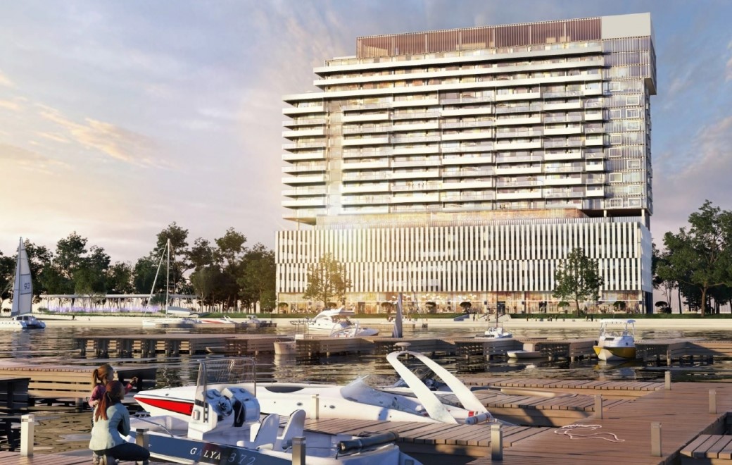


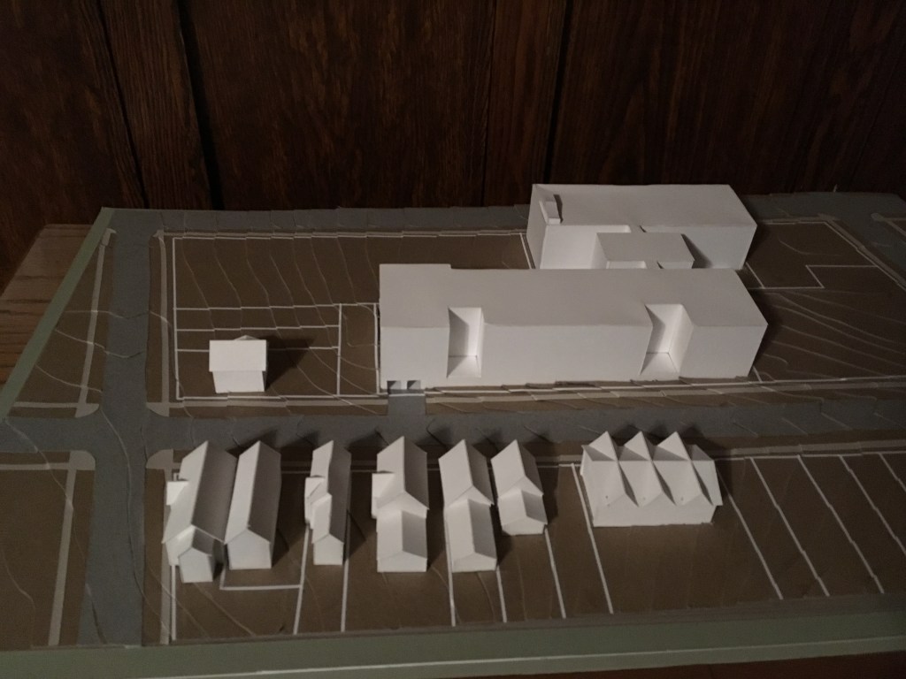

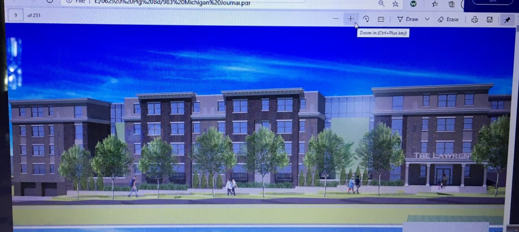


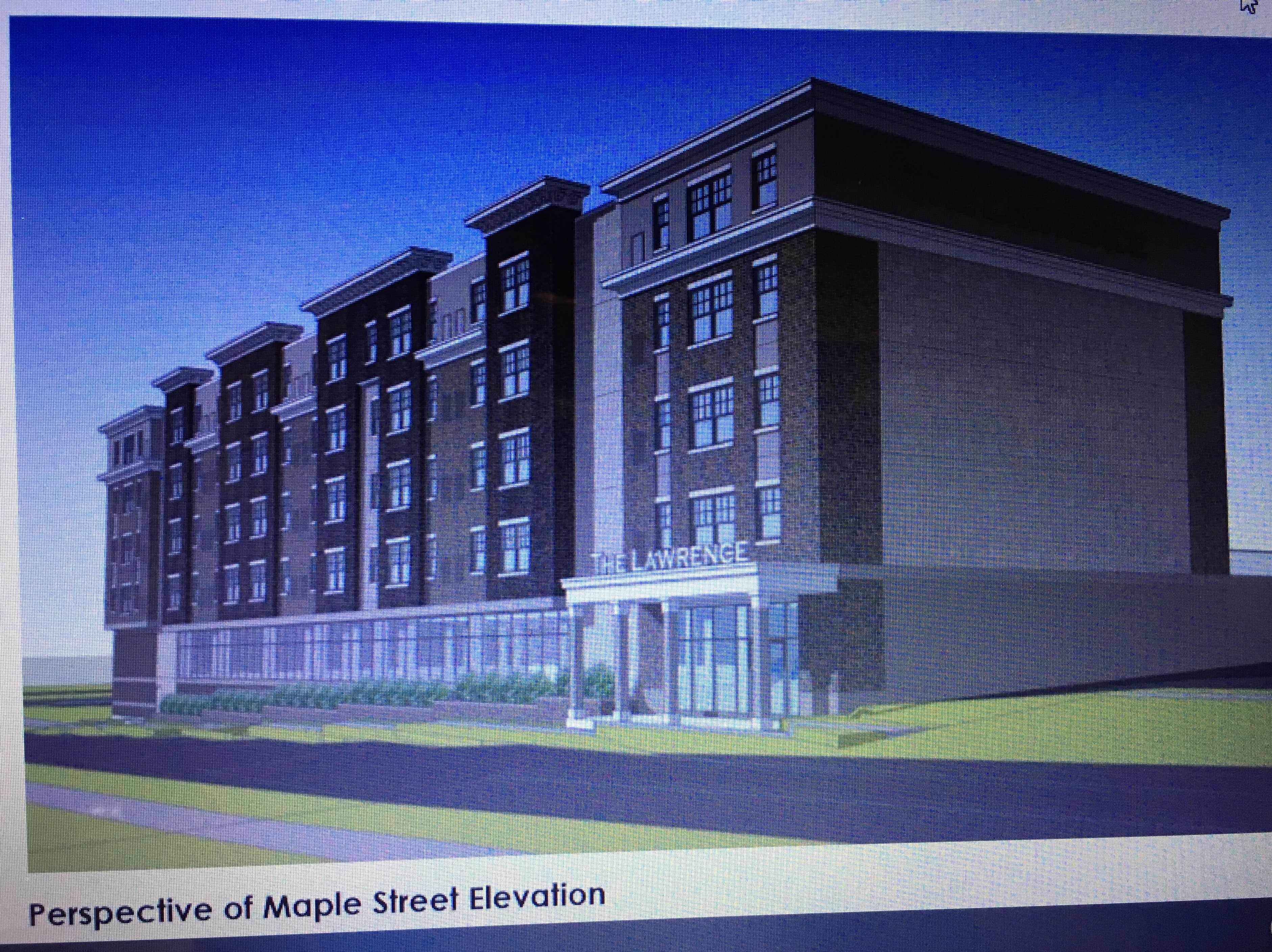

 QCL’s 2016/2017 23-story tower