It was a mere four months ago that Buffalo’s Common Council adopted what appears to be the city’s official goals and policies for waterfront development. The nine-member legislative body approved a resolution the accepted as “complete” the City of Buffalo’s Draft Local Waterfront Revitalization Program [LWRP] on February 2, 2016, and Buffalo’s multi-faceted vision for its coastal area was forwarded to the New York State Department of State for review. [Draft LWRP approval 02-02-2016] As succinctly noted in the 177-page document, “The LWRP policies set general goals for the city’s waterfront as a whole and specific goals for portions of the waterfront that have notable characteristics.” [LWRP, p. “84”]


The City Planning Board has chosen to turn a blind eye to the Common Council’s vision. On May 31, 2016, by a 5 to 1 vote, the administrative body – coaxed on by the City’s Director of Planning, Nadine Marrero – approved the 23-story, mixed-use tower project proposed for the former Freezer Queen site on Buffalo’s Outer Harbor. The project is sponsored by Queen City Landing, LLC, whose principal, Orchard Park businessman Gerry Buchheit, once had grandiose plans for the iconic Statler Towers. [See BUCCHEIT- NORTHSTAR in Bankruptcy Court re Statler.]
The LWRP policies and goals provide the Common Council with the framework for assessing the impacts of a 23-story, 400,000-square-foot project on Buffalo’s evolving Outer Harbor.
The Common Council has an opportunity to correct the Planning Board’s misguided approval of the massive Queen City Landing project.
As the City of Buffalo’s legislative body, the nine elected Council Members – and not the City Planning Board, the Buffalo News editorial staff, or social media commentators – have the authority to determine what is the appropriate use of this Fuhrmann Boulevard site. Currently pending before the Common Council is Mr. Buchheit’s application for a “restricted use permit” under the “Buffalo Coastal Special Review District” ordinance, found at Section 511-67 of the city’s zoning code. [See Buffalo Coastal Special Review District] The purpose of the Coastal Review law is expressed in the following provision:
City of Buffalo Code, Chapter 511 Zoning
Section 511-67 Buffalo Coastal Special Review District
A.(2). Legislative intent.
(a) The Common Council finds that the stability, economic viability and future prosperity of the Buffalo coastal area is being threatened by inconsistent development and by uses not related to the coastal area.
(b) The Common Council further finds that inadequately controlled development may jeopardize a balance of residential, commercial, port-related industrial and public access uses and thus adversely affect the welfare and economic well-being of the City and its residents.
(c) The Common Council therefore finds that future development shall be controlled by the creation of a special zoning district. [Emphasis added.]
In my opinion, the Queen City Landing project is the very embodiment of the “inconsistent” and “inadequately controlled” development the Coastal Review law was meant to restrict.
Here are a number of points I hope the Common Council members will carefully consider:
A. The LWRP provides a specific development concept for the former Freezer Queen site that reuses the existing building while adding a floor or two.
The document approved by the Common Council in February 2016 provides a detailed development concept and rendering for the former Freezer Queen site, one remarkably similar to the plan for which Gerry Buchheit received site plan approval from the City Planning Board in October 2015:

Equally important, the LWRP expressly envisions a “build out” at the Freezer Queen site that includes “Building Reuse,” not the demolition of the existing structure as planned by Mr. Buchheit. [LWRP, p. “25”]
B. Reuse of the existing Freezer Queen facility coincides with the LWRP goal of protecting and enhancing structures and sites that are of significance to the community’s history, architecture or culture.
In sharp contrast to Mr. Buchheit’s desire to demolish the Freezer Queen warehouse and manufacturing building, the LWRP adopted by the Common Council calls for the protection, enhancement and restoration of structures, districts, areas or site “that are of significance in the history, architecture, archeology or culture of the state, its communities or the nation.“
The LWRP requires, “in addition to compliance with historic preservation laws,” consideration of impacts on “Buffalo waterfront heritage themes,” which include “Waterfront industrial heritage resources.” Both the existing structure at the Freezer Queen site, and the adjacent Ford Terminal Complex (a/k/a Terminals “A” and “B”), are among the sites listed in the LWRP as possessing “waterfront heritage resources” reflecting the industrial history of the Outer Harbor. [LWRP, pp. “8” and “9”] This recognition is consistent with the inventory in the “BUFFALO HARBOR Brownfield Opportunity Area” Nomination Document, which specifically identifies the existing Freezer Queen facility as eligible for the State and National Registers of Historic Places.

C. Protecting the overall scenic quality of Buffalo’s coastal area – including unique waterfront landscapes such as marinas, piers, wharfs and mooring areas, waterfront sunsets, and the Great Lakes Seaway Trail Scenic Byway – is an important LWRP policy.
The scenic quality of Buffalo’s waterfront is an aesthetic resource protected by the goals and policies of the city’s LWRP. Proposed projects within Buffalo’s waterfront revitalization area – such as the proposed Queen City Landing development – must be scrutinized to determine whether they are consistent with the goals of protecting and enhancing scenic views, whether the view is natural or manmade, and whether it has local or state-wide significance. [LWRP p. “9”, “16”]
In determining whether a proposed project will further or hinder the LWRP policy objective of preventing impairment of the scenic quality of a waterfront resource, one has to consider whether the development includes “the addition of structures which because of siting or scale will reduce identified views or which because of scale, form or materials will diminish the scenic quality of an identified resource.” [See LWRP’s Buffalo Waterfront Assessment Form (LWRP BWAF), p. “8”.]
The LWRP adopted by the Common Council on February 2, 2016 expressly identifies the following scenic resources that are to be protected and enhanced:
– Unique waterfront landscapes such as marinas, piers, wharfs and mooring areas. [LWRP, p. “9”] The waterfront landscapes identified in Buffalo’s LWRP include the following Outer Harbor resources: Wilkeson Point, the NYPA Outer Harbor Marina, the Small Boat Harbor (with its 1,042 boat slips), and Gallagher Beach. [LWRP, pp. “134” and “135”] In the words of the LWRP: “Buffalo’s marinas are the heart of the community’s engagement with its water.” [LWRP, p. “158”]


– The Buffalo portion of the Great Lakes Seaway Trail National Scenic Byway. [LWRP, p. “9”] The LWRP describes the Great Lakes Seaway Trail as follows: “… [A] 518 mile National Scenic Byway that follows the shores of Lake Erie, the Niagara River, Lake Ontario, and the St. Lawrence River. Within the City of Buffalo, the Great Lakes Seaway Trail follows Niagara Street south to Niagara Square, then south on Delaware Avenue to Route 5 and south to the City line.” [LWRP, p. “158”]
– Waterfront sunsets. As noted in the LWRP: “Located at the eastern end of Lake Erie, Buffalo is the only Great Lakes city to enjoy a view of the sun setting over water.” [LWRP, p. “158”]
D. The Common Council must objectively decide whether the intrusion of a 23-story tower will significantly diminish the enjoyment and appreciation experienced by visitors to the Outer Harbor’s parks, marinas, walkways, and nature preserves that lie within the tower’s expansive viewshed.
The City Planning Board did not conduct a meaningful assessment of the potential adverse impact of the proposed 23-story tower (and three-story parking facility) on the scenic quality of Buffalo’s coastal area prior to approving Mr. Buchheit’s project. Rather, its SEQRA Negative Declaration provides the following unconvincing and conclusory statement:
“Impacts on Aesthetic Resources
Without question the proposed Project is a visually significant deviation from the existing structures in the area. The existing Freezer [Queen] Building is 6-stories tall and the proposed tower will be 23 [stories]. The height of the structure (324’) will be second only to the existing wind farm to the south and on a par with other taller buildings in the urban core. As a result, the proposed building will be a significant visual change from the existing structures.
While the building is located adjacent to Lake Erie, a visual and recreational resource for the area, it is not anticipated to negatively impacts [sic] views despite the degree of change from existing conditions. The proposed structure is a stand-alone building and given the vast stretches of open, publically-owned [sic] lands adjacent to it, the overall viewshed will not be significantly impacted. Therefore, the Planning Board has determined that the Project will not have any significant adverse impacts on aesthetic resources.”

The Planning Board reached a conclusion that defies logic, and abruptly ended the review mandated by SEQRA by issuing a Negative Declaration. Nonetheless, the Common Council has the separate authority and obligation to analyze the proposed project pursuant to the city’s Coastal Review law to determine whether the proposed 23-story tower is the type of “inconsistent development” that may threaten the stability and jeopardize the balance of uses in the Outer Harbor area. Part of that analysis, given the goals and priorities of the LWRP, should include an assessment of the adverse visual and aesthetic impacts of the proposed Queen City Landing project on the Outer Harbor’s designated aesthetic resources lying within the tower’s viewshed.
Note: A viewshed is the geographical area that is visible from a location. It includes all surrounding points that are in line-of-sight of that location and excludes points that are beyond the horizon or obstructed by terrain and other features (e.g., buildings, trees). Conversely, it can also refer to area from which an object can be seen.

Note: The 324-foot tower, with a footprint of approximately 17,500 square feet, would exceed the height of downtown’s HarborCenter by more than 80 feet.
The State DEC has prepared a helpful manual, “Assessing and Mitigating Visual Impacts“, that would provide Council Members with guidance on how to conscientiously identify the relevant inventory of aesthetic resources/scenic landscapes/sensitive places that may be adversely impacted by the proposed development; determine whether the presence of the 23-story tower would have a significant detrimental effect on the perceived beauty of the Outer Harbor or diminish the public’s enjoyment and appreciation of the coastal area’s scenic resources; and, assess whether there are any practicable mitigation measures that would adequately eliminate or reduce the adverse impacts. [See DEC Visual Impacts manual.]
Note: The DEC manual states that consideration must be given to off-site light migration, glare and “sky-glow” light pollution, as part of the assessment of adverse aesthetic impacts. This requirement brings to mind the following land use policy included in the proposed Green Code’s Land Use Plan, under the heading “Protect natural assets”: “Minimize impacts of artificial light on natural systems, and help restore visibility in the night sky.” [Land Use Plan (October 2015) at p. “38”]
Mitigation measures identified in the DEC manual include, for example, relocation of a component of the project to another place within the site; screening, camouflage or disguise; use of building materials that do not shine or reflect light; and, a substantial reduction in the height of the structure.
This latter mitigation measure is of particular relevance under the Coastal Review law given the Common Council’s authority to determine the height of any structure built within the coastal review district:
City of Buffalo Code, Chapter 511 Zoning
Section 511-67 Buffalo Coastal Review District
…
(A)(5) Height restrictions. Any application under Subsection A(4) above shall include maximum heights involved in any use seeking to be established or extended under this subdivision. Such maximum height shall be subject to the approval of the Common Council and, once approved, shall not be exceeded.
E. The City Planning Board allowed itself to be hoodwinked by the sponsor’s misleading and wholly inadequate “migratory bird assessment,” and, in doing so, disregarded the LWRP’s policy calling for “avoidance of disruptions to bird migration to the maximum extent practicable”.
In order to rationally measure the adverse impact Mr. Buchheit’s 23-story, 274,000-square-foot glass and metal tower is likely to have on the migratory bird population that traverse the Buffalo waterfront, one must, at a minimum, know the flight paths of migrating birds, the seasonal patterns of the migrations, and the extent to which the bird populations are moving during the day or at night. It would also make sense to know to what extent, if any, the existing six-story, unlit Freezer Queen building has been an obstruction to migrating birds.
Once armed with such information, a consultant – and a government agency – could then attempt to honestly and objectively assess the adverse impacts a 324-foot tall tower, constructed of glass and metal, would likely have on migrating birds. A conscientious assessment would also analyze the extent to which adverse impacts would be lessened if the proposed building were to be lowered to varios heights.
The City Planning Board did not ask for, and the sponsor of the proposed project did not submit, any such information or analysis prior to the May 31st approval of the 23-story tower. Instead, the Planning Board received a two-and-a-half page “Migratory Bird Assessment & Consultation” report from Mr. Buchheit’s ecological consultant, DIEHLUX, LLC. [See Migratory Bird report] That correspondence does two basic things:
(1) it lists a variety of building design “best practices” that the developer might “potentially incorporate” into the design of the building to lessen the likelihood of migratory bird impacts; and
(2) it provides the following statement apparently meant to suggest that a 23-story tower would have less of an adverse impact on bird populations than a residence or low-rise building:
“… DIEHLUX, LLC cannot rule out that transient migratory birds may occasionally be impacted by this structure during peak migration periods. However, according to recent studies such as Bird-building Collisions in the United States by S.R. Loss, the majority of bird/glass collisions occur at low-rise (1-3 story) buildings (56%) and urban/rural residences (44%). Less than 1% were noted at high rises.”
The City’s Planning Board did not ask Mr. Buchheit’s representatives for additional information. Neither the City’s planning office staff, nor the Planning Board, asked for an estimate of how many migrating birds would be killed by the proposed tower, or a comparison between deaths occurring at the existing Freezer Queens facility and the likely change in numbers if the proposed 324-foot tower were built.
The Planning Board also failed to ask for clarification of the above-quoted statement in the DIEHLUX, LLC report, or, apparently, for a copy of the entire study prepared by S.R. Loss. Had such a request been made, and had the entire 16-page report been available for the public to review, it would have been clear just how misleading it was for the developer’s consultant to imply that high-rise buildings were less of a threat to migrating birds than buildings three or fewer stories in height.
A review of the entire article written by Scott R. Loss (who is employed by the Migratory Bird Center, Smithsonian Conservation Biology Institute, National Zoological Park, Washington, D.C.) [see S.R. Loss article] reveals the following poignant facts:
** The report estimates that between 365 and 988 million birds are killed annually by building collisions in the United State, making building collision mortality one of the top sources of direct anthropogenic mortality of birds in the U.S.
** The report’s mortality estimates may be conservative because data from buildings that cause exceptionally high annual rates of collision were removed from the analysis before extending average rates to the scale of the entire U.S. Hundreds to greater than one thousand birds per year have been found at intensively monitored buildings in or near areas with a high concentration of birds during migration (such as Buffalo’s waterfront revitalization area).
** High-rises cause the lowest total number of bird deaths for one simple reason: there are relatively few buildings taller than eleven (11) stories in height when compared to the number of detached residences and mid-rise buildings. Despite causing the lowest total mortality, high-rises had the highest median annual mortality rate.
** Mortality rates have been found to increase with the percentage and surface area of buildings covered by glass, and with the amount of light emitted from windows.
** Several species exhibit disproportionately high vulnerability to collisions regardless of building type. Seven species that are disproportionately vulnerable to building collisions are national Birds of Conservation Concern and 10 are listed regionally.
** Nearly all high-risk species for low-rise and high-rise buildings are migratory. Compared with resident species, migratory species traverse longer distances, use a greater diversity of habitat types, and encounter more building types and total buildings during the annual cycle. Additionally, migratory species are attracted to large lighted buildings during their nocturnal migration; this attraction causes a large amount of mortality at low-rises and high-rises as birds either immediately collide with lighted buildings or become entrapped before later dying of collision or exhaustion.
** Despite the critical importance of reducing mortality at residences, mitigation measures targeted at a relatively small number of buildings with high per-building mortality rates (e.g., some high-rises and low-rises) will likely result in large per-building reductions in mortality and therefore may represent a cost-efficient starting point for reducing mortality.
Buffalo’s Planning Board (with the exception of Cynthia Schwartz, who opposed both the ending of the SEQRA review without a Draft Environmental Impact Statement, and approval of the project) should be embarrassed by its superficial review of the migratory bird issue. In taking such a cavalier approach to the question of adverse impacts on migrating birds, the administrative board ignored the following policy expressed in the LWRP: “Avoidance of disruptions to bird migration to the maximum extent practicable.” This policy was made a part of the LWRP to not only protect migrating birds, but to also protect and enhance the Lake Erie-Niagara River food web. [LWRP, pp. “3”, “12”]
F. The LWRP seeks to protect, preserve and improve publicly owned areas identified as habitats of state and local significance, as well as the Niagara River Globally Significant Important Bird Area (GSIBA).
The LWRP recognizes that Buffalo’s waterfront area is home to a variety of State-designated coastal fish and wildlife habitats. Habitat designation is based on the area’s fish and wildlife population levels, species vulnerability, ecosystem rarity, human use and replaceability. Three of the State-designated habitats are located in close proximity to the former Freezer Queen site: Times Beach, the Small Boat Harbor and Tifft Nature Preserve. [LWRP, pp. “111” – “114”]

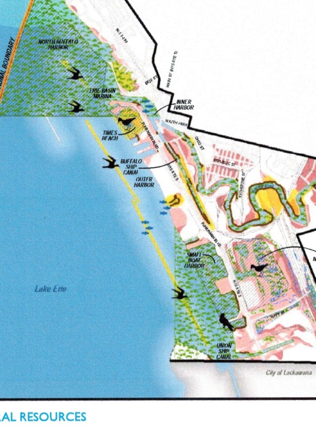
The LWRP also highlights the presence on the Buffalo waterfront of the “Niagara River Globally Significant Important Bird Area” (GSIBA), stating that this is “a rare designation given by National Audubon to only 71 other sites in the world.” [Click here for details about the Niagara River GSIBA.] Accordingly to the LWRP, the Niagara River GSIBA supports one of the world’s most spectacular concentrations of gulls, hosts a remarkable diversity and abundance of waterfowl, and supports breeding colonies of many bird species. It is also the host to an exceptional diversity of migratory songbirds during spring and fall migrations. [LWRP, pp. “115” – “116”] Not surprisingly, then, the LWRP calls for the protection and enhancement of the Niagara River GSIBA.

The Freezer Queen site may not lie within the defined area of the Niagara River GSIBA, but it is part of the gateway to that significant area. Likewise, the 20-acre site may not itself be a designated habitat, but it is part of the Outer Harbor’s interconnected environment. Despite these critical facts, the Planning Board – taking its cue from the developer – has overlooked two concepts that are integral to the goals and policies embraced by the Common Council:
First, the LWRP takes a holistic approach to waterfront revitalization, working to balance inter-dependent interests and “build a sustainable waterfront economy, community and environment.”
Second, Buffalo’s waterfront revitalization area serves as “an informal regional wildlife preserve” where the Lake Erie-Niagara River food web must be protected and rebuilt. [See, “Goal 1. Holistic Coastal Program” at LWRP p. 3; “Goal 7. Protect and Rebuild the Lake Erie/Niagara River Food Web” at LWRP, p. 11.]
The integral role played by the designated coastal fish and wildlife habitats near the Freezer Queen site cannot be overstated.
The Small Boat Harbor is “the largest, most obvious nursery area for numerous harbor and lake species on the Erie County shoreline,” and “provide(s) valuable food resources for many species of waterfowl and migratory birds.” It attracts concentrations of these birds during spring and fall migrations, with some species remaining until the harbor freezes in early to mid-winter. Prior to ice-up, the Small Boat Harbor serves as a refuge and feeding area for some of the larger concentrations of waterfowl in the North Buffalo Harbor (located at the head of the Niagara River). [LWRP, pp. “113” – “114”]
Times Beach Nature Preserve – located one mile southwest of downtown Buffalo – is a 55-acre fish and wildlife habitat. Due to its location on the eastern end of Lake Erie, it is “a critical geographical feature for bird migration north in the spring and south in the fall,” where more than 220 species of birds have been observed. [LWRP, p. “111”]
Buffalo’s LWRP expressly calls for the protection and enhancement of the Niagara River GSIBA, and asks that any review of a proposed project consider two critical factors:
(a) “Protection and enhancement of bird habitat areas;” and
(b) “Avoidance of disruption to bird migration to the maximum extent practicable.” [LWRP, p. “12”]
Of equal importance, the LWRP acknowledges that its policies seeking to rebuild the Lake Erie-Niagara River food web, and to protect, preserve, and improve coastal fish and wildlife habitats of both state-wide and local significance, “will also contribute to the protection of the City’s globally significant bird area, and rare, threatened and endangered species.” [LWRP, pp. “11” and “12”]
In light of the paramount role played by the Small Boat Harbor and Times Beach in the overall well-being of Buffalo’s waterfront ecology, the two-and-a-half-page migratory bird “assessment” submitted on behalf of Queen City Landing, LLC, and the Planning Board’s anemic assessment of “impacts on plants and animals,” are woefully deficient.
G. The Common Council must objectively decide whether the traffic and activities that would be generated by the proposed 400,000-square-foot, mixed-use facility will significantly diminish the enjoyment, appreciation, and safety of visitors to the Outer Harbor, in particular, users of the public bike path that runs along the frontage of the project site.
Developers and their consultants strive to limit the assessment of a proposed project’s traffic impacts to a technical discussion of “Levels of Service” (LOS) and highway “capacity.” While that may be a useful gauge of adverse impacts for a project a developer wishes to build at, say, the corner of Elmwood Avenue and W. Delevan, we are dealing here with a totally different situation. The mammoth Queen City Landing project is proposed for an Outer Harbor site located between nature-enhanced areas such as the Greenway Nature Trail, Wilkeson Point, and Times Beach to the north, and the Small Boat Harbor and Gallagher Beach to the south. For many a Buffalonian and visitor, the preferred route by foot or bicycle between the various Outer Harbor destinations is the public bike path that runs along the frontage of the former Freezer Queen site.
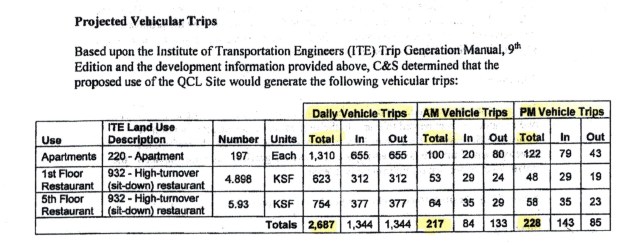
The traffic analysis submitted on behalf of Queen City Landing to the City Planning Board estimates that the 197 apartments and two restaurants proposed by the developer would generate 217 vehicles entering or exiting the site during the AM peak hour, 228 vehicles entering or exiting the site during the PM peak hour, and a total of 2,687 vehicles entering or exiting the property on the typical weekday.
To phrase this another way, Outer Harbor visitors traversing the public bike path adjacent to the front of the Queen City Landing development would experience the following:
** During the morning peak hour, a vehicle entering or exiting the site every 16.6 seconds.
** During the afternoon peak hour, a vehicle entering or exiting the site every 15.8 seconds.
** And, if we were to make the admittedly unrealistically assumption that traffic coming in or out of the Queen City Landing development would be evenly spread out over a 24-hour period, a vehicle entering or exiting the site every 32 seconds, twenty-four hours a day.

Given the potential conflict such a constant traffic flow would create for individuals, families, and groups seeking pleasure, exercise, and the unique waterfront experience offered by the Outer Harbor amenities, the Common Council must decide the extent to which Mr. Buchheit’s proposal – if not substantially reduced in scale – will hinder attainment of the following LWRP policies:
– Protect, maintain and increase the levels and types of access to public water-related recreation resources and facilities. [LWRP, p. “13”]
– Water dependent and enhanced recreation shall be given priority over non-water-related uses along the coast. [LWRP, p. “13”]
With All Due Respect,
Art Giacalone